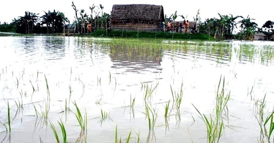
RANGPUR, Sept 30, 2030 (BSS) – The current flood has submerged standing crops on 49,011 hectares of land in all five districts under Rangpur agriculture region.
Officials of the Department of Agricultural Extension (DAE) said there is less chance of submergence of more standing crops as flood situation might remain mostly stable from tomorrow to begin improving with recession of floodwater within the next few days.
Acting Additional Director of the DAE for Rangpur region Agriculturist Md. Moniruzzaman today told BSS that reports of crop damages would be available from affected areas after recession of floodwater from across the region.
The submerged standing crops on 49,011 hectares of land include 18,330 hectares of land in Rangpur, 7,195 hectares in Gaibandha, 18,500 hectares in Kurigram, 1,356 hectares in Nilphamari and 3,630 hectares of land in Lalmonirhat districts of the region.
Moniruzzaman said the government would assist flood-hit farmers in recouping crop losses through cultivating other substitute crops like early varieties of winter vegetables and other crops on their submerged croplands after recession of floodwater.
“A major portion of submerged crops in Kurigram and Gaibandha might be damaged for remaining inundated since September 22 while in other affected districts of the region might suffer less damage following quicker recession of floodwater,” he added.
Bangladesh Water Development Board (BWDB) officials said major rivers, except the Teesta, Dharla and Jamuneswari, marked further rise inundating fresh low-lying areas and standing crops in the basin during the last 24 hours ending at 9 am today.
The Brahmaputra, Jamuna, Ghagot and Kartoa marked further rise despite no rainfall during the last 24 hours in both the upstream northeastern Indian states and downstream of the Brahmaputra basin.
According to the BWDB’s Flood Forecasting and Warning Centre’s flood situation bulletin, water levels of the Brahmaputra-Jamuna river systems are in rising trend and might remain steady in the next 24 hours.
BWDB officials said water levels of the Jamuneswari fell by 12cm at Badarganj, Kartoa further rose by 18cm at Chak Rahimpur, Ghagot by 5cm at Gaibandha and Jamuna by 3cm at Sariakandi while Dharla fell by 16cm at Kurigram points during the last 24 hours.
The Jamuneswari was flowing above the danger mark (DM) by 65cm each at Badarganj, Kartoa by 95cm at Chak Rahimpur, Ghagot by 3cm at Gaibandha, Jamuna by 11cm at Sariakandi and Dharla above the DM by 5cm at Kurigram points at 9am today.
Meanwhile, water levels of the Brahmaputra rose by 8cm at Noonkhawa and 9cm at Chilmari during the last 24 hours and were flowing below the DM by 59cm and 14cm at these points respectively at 9am today.
During the period, water levels of the Jamuna rose by 7cm each at Fulchhari and Bahadurabad, 2cm at Kazipur and 1cm at Sirajganj and were flowing below the DM by 14cm, 19cm, 2cm and 16cm at these points respectively at 9am today.
However, water levels of the Teesta remained steady at Dalia and fell 5cm at Kawnia during the period and were flowing below the DM by 55cm and 45cm at these points respectively at 9am today.
Talking to BSS, Chief Engineer for Rangpur Zone of BWDB Jyoti Prosad Ghosh said the flood situation might remain steady in Kurigram and Gaibandha and improve further in Rangpur, Nilphamari and Lalmonirhat districts during the next 24 hours.


