DHAKA, July 29, 2020 (BSS) – Water level of the rivers in the Ganges basin continues to swell up due to the onrush of water from upstream, deteriorating flood situation further there.
Of 30 river points monitored in Ganges basin, water levels went up at 15 stations, while receded at 13 stations and remained stable at two points at 9 am today, according to the data of Bangladesh Water Development Board (BWDB).
The rising trend of water levels was recorded at Pankha, Rajshahi and Hardinge Bridge points in the past 24 hours ending 9 am today, BDWB superintending engineer Mukhlesur Rahman told BSS.
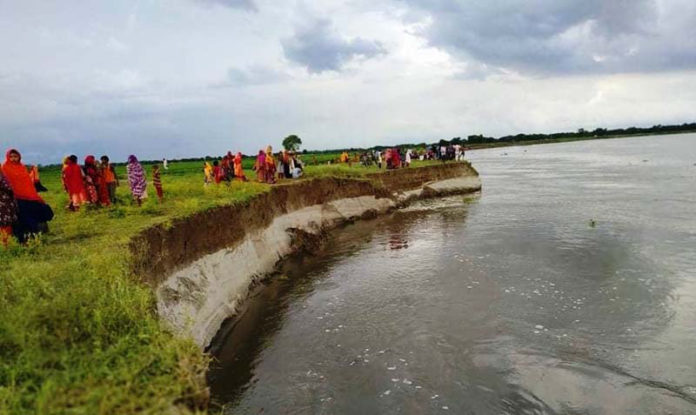
Arable land, homesteads and other infrastructures are going under the water of Padma River due to severe riverbank erosion.
A one-storey building of Basakerchar Government Primary School under Naria upazila in Shariatpur district went under the water of Padma River at 2 pm today.
Besides, 50 homesteads of the area were devoured in the river today. In the last 12 days, the Padma River gobbled up 496 homesteads, four mosques and a madrasa, in Janjira and Naria upazilas, BSS Shariatpur correspondent reports.
About 403 homesteads of Kunderchar, Barakandi and Naodoba unions of Janjira upazila and 45 homesteads of Charatra union of Naria upazila have so far went under the water of the Padma River.
Naria Upazila Nirbahi Officer (UNO) Jayanti Rupa Roy said a one-storey building of Basakerchar Government Primary School was washed away due to erosion of the Padma River today.
“Another two-storey building is also at risk of collapse due to riverbank erosion there. In addition, 50 homesteads in Basakerchar went under the river water today,” she said.
The UNO added that a process continues to provide assistance for the victims of erosion-prone areas by preparing a list.
Water levels of the Ganges River increased by two cm at Pankha point in Chapainawabganj and Hardinge Bridge point and three cm at Rajshahi, while the water level of the Padma River decreased by five cm at Goalunda point.
But, the Ganges River was flowing 164 cm, 156 cm and 75 cm below the danger level at Pankha, Rajshahi and Hardinge Bridge points respectively, he added.
Besides, the water level of the Korotoa River and the Jamuna River flowing in Bogura and Sirajganj districts under the Brahmaputra Basin were reported a receding trend this morning.
Arifuzzaman Bhuiyan, executive engineer of Flood Forecasting and Warning Centre (FFWC), said the water level of the Korotoa River increased by one cm at Bogura point, while decreased by 24 cm at Chak Rahimpur.
The river was flowing 146 cm and 29 cm below the danger mark at the two stations respectively this morning, he said.
The Jamuna River water level decreased by 18 cm at Sariakandi in Bogura, 22 cm at Kajipur in Sirajganj and 13 cm at Sirajganj point, but the river was still flowing 82 cm, 62 cm and 60 cm above the danger mark at Sariakandi, Kazipur and Sirajganj points respectively.
The water level of the Gur River decreased by one cm at Shingra point in Natore and the river was flowing 90 cm above the danger mark. The Atrai River was flowing 107 cm above the danger level at Baghabari point in Sirajganj with five cm fall afresh this morning.
The Atrai River was still flowing 11 cm above the danger mark at Atrai point in Naogaon with seven cm fall afresh.
BSS Rangpur correspondent adds: The flood situation improved further in the Brahmaputra basin as no rain was recorded in the northwestern Indian states during the last 24 hours ending at 9 am today.
The BWDB officials said water levels of all major rivers, except Dharla and Teesta, marked further fall due to dwindling of onrush of hilly water from the upstream.
Despite continuous fall in water levels during the past couple of days, the Dharla, Ghagot, Brahmaputra and Jamuna rivers were still flowing above the danger level at eight points.
The FFWC predicted that the flood situation may continue to improve in Kurigram, Gaibandha, Bogura, Jamalpur and Sirajganj districts during the next 24 hours.
The Brahmaputra was flowing 28 cm above the danger level at Chilmari, while the Dharla River 7 cm above at Kurigram and the Ghagot River 38 cm above the danger mark at Gaibandha point at 9 am today.
The Jamuna was flowing 61 cm above the danger level at Fulchhari point, while 72 cm above at Bahadurabad point, 82 cm above at Sariakandi point, 62 cm above at Kazipur and 60 cm above at Sirajganj points.
BWDB executive engineer Mokhlesur Rahman (Gaibandha division) said sporadic incidents of riverbank erosion are being reported at some vulnerable points where protection works continues.


