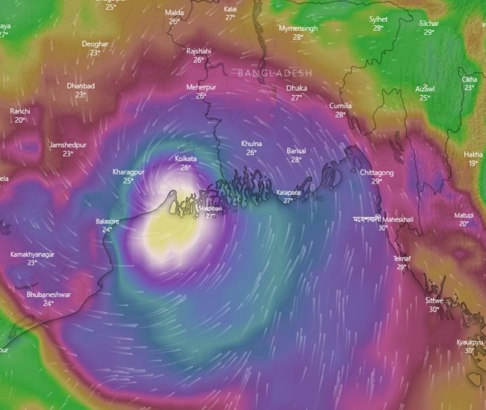
DHAKA, May 20, 2020 (BSS) – Disaster management authorities today said they eventually evacuated over two million vulnerable people to safert mostly in southwestern coastlines as super cyclone Amphan is set to make its landfall in hours.
“So far 2390,307 people have been moved to safety long with over half a million cattle,” state minister for disaster management Enamur Rahman told a virtual media briefing in the afternoon.
He added that the increased number of people, even surpassing a target, prompted authorities to increase the number of cyclone shelters from 12,078 to 14,336″ in 19 of the southern coastal districts.
He reconfirmed that the local authorities ensured adequate food and children food for the people in the shelters in many cases with their cattle as well.
But reports of casualties and damages like embankment breach started appearing to the news desk while the country awaited the main brunt of the deadliest cyclone in decades.
A Bangladesh Red Crescent Society (BDRC) volunteer appeared to be the first victim of Amphan as inclement weather capsized a boat he was travelling to evacuate villagers to safety in southwestern Patuakhali, officials said.
“He was on a boat along with four others while a sudden storm under advancing Amphan’s influence overturned . . . three others managed to swam ashore but our Syed Shah Ali could not make it,” BDRC’s cyclone preparedness programme Nurul Islam Kan told BSS.
He said 50-year Ali drowned visibly because of his heavy gumboots, raincoat and a super megaphone he was carrying as the accident came hours ahead of the expected landfall of Amphan on Bangladesh’s southwestern bordering India’s West Bengal.
Meanwhile, onrush of waters washed away some 740 houses in 15 villages in Patuakhali’s Rangabali and Kalapara upazilas as an advanced surge of tide cracked a coastal embankment while the cyclone was approaching with its main brunt, officials said.
The met office in its early morning bulletin issued its highest “Great Danger Signal” for the regions under the purview of the southwestern Mongla and Payra ports, replacing the previously issued mere “Danger Signal”.
In a subsequent midday bulletin it issued the identical Great Danger Signal for the countries rest two seaports of Chattogram and Cox’s Bazar and their adjoining southwestern regions.
Meteorologists said in a scale of 11, great danger signal no 8, 9 and 10 carry identical meaning in terms of intensity while the numbers differ only to indicate approaching storms’ directions.
Signal no. 11 is called Communication Failure Signal No. XI, indicating severed communications of the meteorological warning centre to the affected region.
The meteorologists said the world largest mangrove forest, the Sundarbans, was likely to absorb the main brunt of the Amphan onslaughts as it did many times over the centuries, including that of the recent major storms, to minimise human casualties.
“The Sundarbans always absorbed the brunt of cyclones whichever hit the coastlines alongside the Bangladesh-India, we expect the forest to face the initial impact of Amphan like foot soldiers this time as well,” Bangladesh’s meteorology department director Shamsuddin Ahmed earlier told newsmen.
According to the latest met office bulletin issued this afternoon the cyclone was located at about 420 km southwest of north-eastern Chattogram, 430 km southwest of north-eastern Cox’s Bazar,200 km southwest of southwestern Mongla and 250 km southwest of southwestern Payra ports.
The met office predicted its landfall in between 4-8 pm BST while calculated the maximum sustained wind speed within 80 kms of the cyclone centre to be about 180 kph rising to 2oo kph in gusts/squalls.
Amphan coinciding with the influence of the end day of last quarter moon could inundate low-lying areas of coastal Satkhira, Khulna, Bagherhat, Jhalokathi, Pirojpur, Borguna, Patuakhali, Bhola, Barishal, Laxmipur, Noakhali, Feni, Chattogram and their offshore islands and shoals under as high as 19 feet high tides beyond the normal astronomical ones.
The bulletin reiterated that these mostly southwestern and central coastal region were likely to experience simultaneously strong winds speeding up to 140-160 kp/h in gusts or squalls with heavy to very heavy rain falls during the passage of the cyclone.
The Indian met office in its latest bulletin made identical observations adding that the “extremely severe cyclonic storm” was likely to move north-northeast wards and cross Bangladesh-West-Bengal coast between West Bengal’s Digha and Bangladesh’s Hatiya, close to the Sundebans during late afternoon today.
The US-based global storm tracker AccuWeather said after weakening some on Tuesday, Amphan was expected to continue this trend as it approaches the head of the Bay of Bengal into Wednesday.
“While some additional weakening is expected just before Amphan makes landfall, the cyclone will still be a dangerous storm,” it said.


